Maps at the Library & Archives
Digitized images of some of the thousands of rare and historical maps held at the Library & Archives.


Maps are invaluable components of historical and genealogical research, and documentary records often cannot be fully understood without referring to maps. The Library & Archives has the largest and most significant collection of historical maps in the state available for public use. We hope to increase utilization of this tremendous research resource by digitizing original manuscript maps and making them available online. These digitized maps appear in the JPEG2000 format, which means that you may view them in greater detail by using the Zoom tool and Expanded View option to navigate to a particular area of the image. We will continue to add maps to this digital online collection to bring more of them to a wider public.
Anyone looking for other maps (those not yet scanned) should consult the thousands of record-only entries in this collection, and talk with an archivist. If you open or "Browse the Collection," you will see records for our scanned maps followed by a great many non-image (or metadata-only) records. If you use the "Search" bar to narrow your results, those results will display scanned and non-image map records mixed together. The non-image entries will provide certain information about particular maps: Title, Description, Dimensions, and Location - where the map can be found in our collections. Armed with that information, users can consult with a Public Services archivist about access to that particular map. Many important maps are part of individual manuscript collections and record groups and are not yet digitized.
For additional assistance, please consult the Manuscripts staff in-house or Ask Us a Question via email or chat.
HOW CAN I LOCATE A PARTICULAR COMMUNITY, STREAM, SCHOOL, CHURCH OR CEMETERY?
Often features like streams, cemeteries, and churches, that are still present, are best located on modern maps such as county highway maps and the U.S. Geologic Survey topographic maps. Both types of maps are quite detailed and go to great lengths to name most features, so they can be useful for identifying creeks named in old deeds, hollows and roads named after a particular family, or historic cemeteries. Volume 4 of the Omni Gazetteer provides a simple, statewide index to all place-names in Tennessee and identifies the quadrangle map on which a particular feature can be found. If a place-name has completely disappeared from the modern landscape, then it may be necessary to use an older map to identify the earlier site, in conjunction with a published finding aid such as Morris and Rhea 's Tennessee Gazetteer 1834, the guide to Tennessee Post Offices and Postmasters, or a county history. One group of older maps that is especially thorough and precise in its naming of features is the Division of Geology series, done for various Tennessee counties between 1915 and 1935. The Post Office - Rural Free Delivery county maps in this series are also very useful for locating historic roads, communities, and even residences.
WHERE IS A PARTICULAR CIVIL DISTRICT?
There is a series of 1836 maps for many counties that shows civil district boundaries with descriptions. The Beers Company demographic maps and the Division of Geology - Post Office series also show the configuration of civil districts at particular times. Census compendia (1870 and 1880) and descriptions of census enumeration districts (1900 and 1910) can provide communities and place-names associated with certain civil districts. All these sources must be used with caution, since civil district boundaries may shift frequently. Boundary line changes may be gleaned from the Acts of Tennessee.
WHERE DID MY ANCESTOR LIVE?
Between 1871 and 1907, the Beers Co. of Philadelphia did a series of maps of Tennessee counties showing landowners' names and the approximate location of their farms. These maps are available for Bedford, Davidson, Gibson, Giles, Hamilton, Haywood, Knox, Madison, Marshall, Maury, Montgomery, Rutherford, Shelby, Sumner, Williamson, and Wilson Counties. There are two Civil War maps for Middle Tennessee (Maps #139 and #2519) that show farmers' names on the land. We also have a set of 1939 - 1941 TVA land ownership maps (Record Group 70, mf.) showing the names of property owners and the boundaries of their property over much of the Tennessee Valley. Other than finding their ancestor's name on one of these maps (a rough approximation, at best), the best way for a researcher to learn the precise location of an historic homestead is to do a property title search through careful use of the deeds and related records.
WHERE WERE PARTICULAR ROADS, FERRIES, CAMPS, RAILROADS, AND OTHER HISTORIC FEATURES?
Early statewide maps, such as those of Matthew Rhea (1832), the District Surveyors (1806 - 1819), and the Civil War engineers provide good depiction of the road system, ferries, communities, and churches. Specialized maps will show the locations of Civil War camps, railroads, iron furnaces, river landings, etc. The best maps for locating extant cemeteries (other than small family burial plots) are the modern county highway maps.
We do not have maps of early land grants in Tennessee, except for scattered plat books and drawings for certain locales. The plats for the North Carolina military grants are included with the warrants of the Secretary of State's Land Office in Raleigh, N. C. (Mf. 1177).
The Map Database is up-to-date with respect to the collection. Every effort is made to consolidate our map collection by bringing newly discovered or out-of-the-way maps to the attention of an archivist, so that they may be copied and added to the Map Collection. This is especially true for fragile, folded maps tucked away in older published sources. There are many atlases, fire insurance plat books, and maps in the Congressional Series whose handling and copying by patrons should be limited. Library staff should exercise caution in pulling such early editions from the stacks, particularly since the maps they contain are often available in microfilm or microfiche.
An effort has been made to represent here the myriad sources of maps in the Library & Archives collections, as well as to present certain series of maps that are particularly useful for genealogical and historical research. As to sources, the Maps at the Tennessee State Library and Archives displays maps that are drawn from manuscript collections, state record groups, the Congressional Serial Set, published volumes in the State Library collections, as well as the physical Map Collection itself. Obviously, with thousands of maps in our holdings, the items presented in this online digital map collection are but the 'tip of the iceberg,' and researchers are strongly encouraged to consult archival staff, the Library & Archives Map Database and individual collection finding aids to find the right map. One of the strengths of our collection --Civil War Maps--is treated separately below.
We have included a number of significant early maps of the Tennessee country, beginning with colonial-era maps of British possessions that show the Native American towns and villages of the Cherokee, Creek, and Chickasaw nations. Several maps are presented from about the time of statehood--1796--which show Tennessee as it was originally constituted: two non-contiguous areas of settlement consisting of the middle and eastern Tennessee counties, separated by Indian territory. A series of the so-called District Surveyor's maps are here from 1806 onward, showing the division of newly acquired (by treaty) public lands into ranges and sections so that the State of Tennessee could make (sell) land grants. Thereafter, there are state maps from 1818 and the 1820s showing the rapid development of western Tennessee.
Aside from the Civil War maps in this collection, there is a sampling of other military maps spanning from the American Revolution to the Plains Indian wars of the 1870s. A very fine Paris-published map from the eighteenth century depicts the land and naval campaign that resulted in the French-American victory over Lord Cornwallis' British army at Yorktown and effectively won America's independence. Another hand-drawn map on linen shows the disposition and movement of US Cavalry and Sioux and Cheyenne warriors at the 1876 Battle of the Little Bighorn, apparently done by someone who was there or had close knowledge of the battle.
The bulk of the maps in this presentation are ones of individual Tennessee counties that contain a wealth of detail and are especially useful for genealogical and local historical research. There are three main series of early twentieth century maps represented here: county postal delivery maps, county maps produced by the state Division of Geology, and county soil survey maps. The latter two types are based on US Geological Survey topographical map data and, consequently, are extremely detailed down to the level of individual house structures and name most topographical features (streams, ridges, hollows, etc.) as well as human features such as churches, schools, stores, mills, cemeteries and even very small communities. The postal maps, done presumably for carriers in the early days of Rural Free Delivery (RFD), are similarly very detailed down to the level of individual houses and buildings and provide a great many names of land and homeowners. These county maps, which are done at different times from 1900 to 1940, show many bygone features and are indispensable guides to the rural landscape of Tennessee before modernization changes everything.
Other series of historical maps from the Library & Archives Map Collection, as well as special maps from lesser known manuscript sources in our collections, will be added to this digital collection on a regular basis.
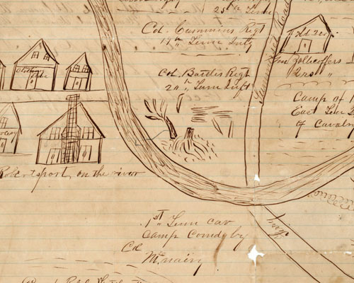
Military maps have always played a crucial role in planning strategy, designing battle plans, and finding the best points for supply routes or even a retreat. This was no more evident than in the Civil War where large armies--particularly Federal ones--traversed a vast Southern landscape unfamiliar to most commanders. Knowing the roads to and from the sites of military engagements, as well as the topography of the locality, was indispensable in conducting war maneuvers. Generals on both sides understood the advantage conveyed by having good, accurate maps of the theater of operations.
Today, Civil War military maps are used by historians and researchers to analyze all kinds of data: troop positions, defensive structures, roads, ferries, encampments, local buildings, and topography. A number of battle maps provide information about a locality that is not otherwise available, such as the configuration of small towns, the location of plantations, and the names of landowners in the area. Those interested in cartography find Civil War maps to be an endless source of fascination as the first truly modern maps of America. Civil War maps offer a unique glimpse of the nation's most portentous conflict.
Union forces clearly had the advantage when it came to maps, as there were already mapping units in existence. These included the Army's Corps of Topographical Engineers, the Corps of Engineers, the Treasury Department's Coast Survey, and the Navy's Hydrographic Office. Mapping began in earnest when Federal troops occupied key positions. These units provided the necessary equipment and a trained workforce. Army personnel worked in a concerted effort with topographical engineers to update old maps, utilizing the latest printing techniques and using new devices for gathering information, including the establishment of a balloon corps that made sketches and maps from an aerial point of view.
By comparison, Confederate mapping was woefully inadequate throughout the war. Besides a dearth of trained cartographers, there was a lack of government mapping agencies, inadequate printing facilities, and an almost total absence of surveying and drafting equipment. Survey parties were often sent out into the field where maps were hurriedly drawn in ink on linen to be traced later. Tracing copies took an inordinate amount of time but Confederate cartographers could not afford the expense of producing lithographs. The Confederate Topographical Department, in response to this dilemma, began making photo-reproductions.
Some Union topographical engineers became noted for their superior map making; their work is reflected in several examples on this site. William E. Merrill belonged to the Union Corps of Engineers but, ironically, was not a topographical engineer. He served in the Army of the Potomac, then under General William S. Rosecrans, and, finally, in the Army of the Cumberland led by General George H. Thomas. Merrill and another Union cartographer named Orlando Poe were meticulous in their drafting and supplied the best maps of either army in the Civil War. Nathaniel Michler was a captain of topographical engineers in the Army of the Potomac from 1863-1865. Michler surveyed and mapped numerous operations and fields of battle. Like Merrill, he was a graduate of West Point. Another Federal topographical engineer of note was Lieutenant Harry C. Wharton, who served in the Army of the Cumberland. All produced valuable, detailed wartime maps of Tennessee represented in this collection.
Confederate cartographers represented in this exhibit are Wilbur F. Foster and C. Meister, an apprentice engineer and draftsman in General Braxton Bragg's Army of Tennessee. A Confederate engineer named Albert Martin produced a beautiful map of the Confederacy's early fortifications on the Mississippi River above Memphis. The featured maps include the pivotal battles at Fort Donelson, Stones River, Franklin, and Nashville. Especially interesting are a number of operational maps of middle Tennessee and north Georgia that belonged to Confederate general and Army of Tennessee corps commander Benjamin F. Cheatham.
After the war, commercial mapping enterprises found a lucrative market in a public eager to know where the engagements of the war had been fought. Battlefield maps and panoramic maps were produced for public consumption, with some maps incorporating portraits of military leaders. Often maps printed from woodcuts could be found in newspapers and journals. A number of Civil War battlefield maps in this collection were produced as studies or plans prior to the establishment of national military parks.
In addition to maps held at the Tennessee State Library and Archives, the digital collection, Looking Back: The Civil War in Tennessee, is the Library & Archive's digital-only collection that includes a number of significant Civil War maps from private owners across the state of Tennessee. Two were drawn by Confederate and Union soldiers who were at Gettysburg and Spring Hill, respectively, and an 1862 map of West Tennessee by a Union cartographer, L. D. Radford.
Bosse, David C. Civil War Newspaper Maps: A Historical Atlas. Baltimore: Johns Hopkins University Press, 1993.
Civil War Maps in the National Archives. Washington, DC: National Archives and Records Service, 1964.
Cowles, Calvin D., comp. The Official Military Atlas of the Civil War. New York: Fairfax Press, 1983.
McElfresh, Earl B. Maps and Mapmakers of the Civil War. New York: Harry N. Abrahms, Inc., 1999.
McPherson, James M. The Atlas of the Civil War. New York: Macmillan, 1994.
The Official Atlas of the Civil War. New York: Thomas Yoseloff, 1958.
Stephenson, Richard, comp. Civil War Maps: An Annotated List of Maps and Atlases in the Library of Congress. 2nd ed., Washington, DC: Library of Congress, 1989.
Symonds, Craig L. A Battlefield Atlas of the Civil War. 2nd ed., Baltimore: Nautical & Aviation Publishing Co., 1985.
Woodworth, Steven E. and Kenneth J. Winkle. Atlas of the Civil War. New York: Oxford University Press, 2004.